
GARDEN ROUTE | KAROO NEWS - According to the South African Weather Service, a well-developed cold front associated with a cut off low pressure system is expected to reach western parts of the Western Cape on Saturday, moving across the central interior on Sunday through to Monday.
The public and small stock farmers are advised that cold to very cold conditions, wet and windy with snowfall on high lying areas of the Cape Provinces and western parts of KwaZulu-Natal as well as Free State province with possible very rough seas and strong winds along the coast.
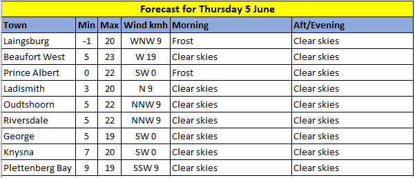
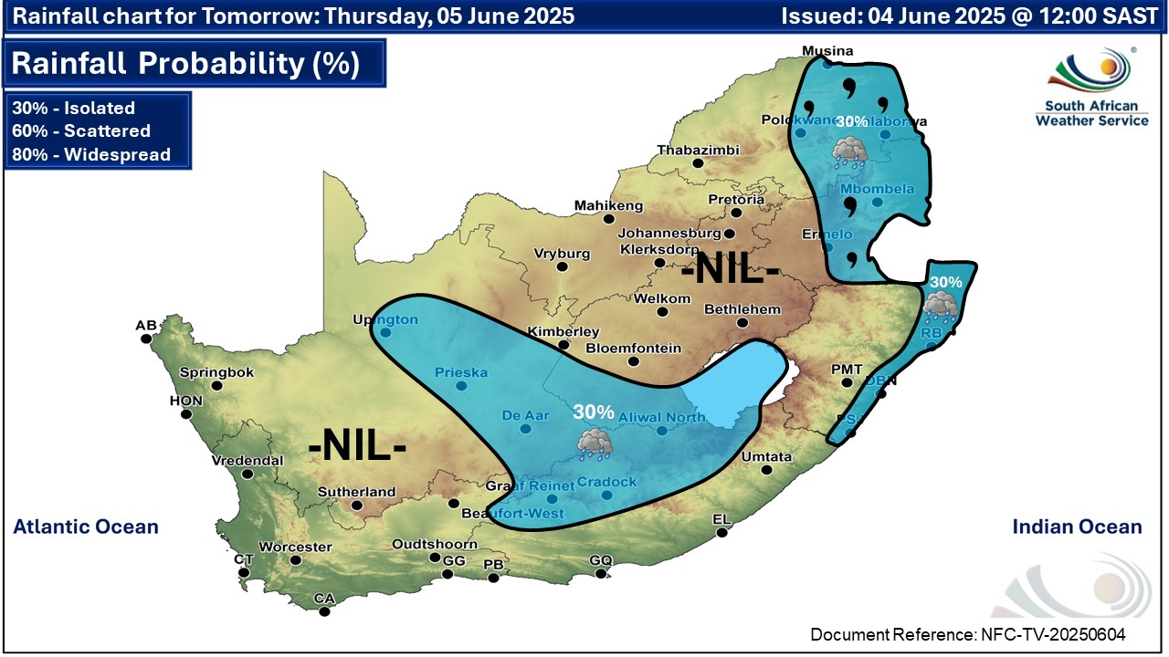
Here is what you can expect on Thursday, 5 June:
Western Cape
Fine and cool to cold with morning frost in places over the interior. The wind along the coast will be light to moderate north-easterly in the south and south-west but south to south-westerly in the west. The expected UVB sunburn index: Low
Western half of the Eastern Cape
Morning fog patches in places over the interior, otherwise partly cloudy and cool with isolated thundershowers in the north. The wind along the coast will be fresh to strong north-easterly, becoming light to moderate from the evening.
Morning fog patches in places over the interior, otherwise partly cloudy and cool with isolated thundershowers in the north. The wind along the coast will be fresh to strong north-easterly, becoming light to moderate from the evening.
Eastern half of the Eastern Cape
Morning fog patches south of the escarpment, otherwise fine and cool becoming partly cloudy with isolated thundershowers in the north. The wind along the coast will be Fresh to strong north-easterly.
Morning fog patches south of the escarpment, otherwise fine and cool becoming partly cloudy with isolated thundershowers in the north. The wind along the coast will be Fresh to strong north-easterly.
Expected weather conditions:
‘We bring you the latest Garden Route, Hessequa, Karoo news’