AALWYNDAL NEWS - An in-depth biodiversity study is taking place in Aalwyndal after it was identified as an intensification node and one of the main urban expansion areas for Mossel Bay.
This identification forms part of the Mossel Bay Spatial Development Framework of 2018 and 2022. As it formed part of the framework, the Mossel Bay Municipality formally adopted the Aalwyndal Precinct Plan as a guide document for development in Aalwyndal.
In light of new information from the study, however, plans for development might be influenced due to the identification of highly sensitive biodiversity areas.
Available information
The municipality said based on the information available at the time of Aalwyndal being identified for development, it was believed that:
• the location of the area within the urban context,
• the existing land use rights and
• the proximity to existing roads and other municipal infrastructure,
would result in a development which will service the future needs of Mossel Bay residents.
Legally, landowners and developers may proceed with submitting the necessary land development authorisation applications accordingly.
The biodiversity study started in May 2024 after funding was made available by the Western Cape Provincial Government.
The municipality said the sensitivity mapping is one outcome of a much bigger study which is not completed or available yet.
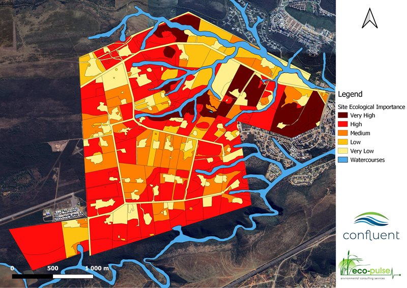
Sensitivity criteria
Mossel Bay Advertiser asked the municipality to elaborate on the criteria for sensitivity.
"Although the habitat as a whole is discussed in the document, the sensitivity mapping is mainly based on vegetation type and aquatic features like water courses.
"The classification was done by environmental specialists. Although several criteria were used the main criteria are vegetation type and the natural state of the vegetation and habitat.
"Totally undisturbed vegetation of highly endangered species will therefore be classified as of very high ecological importance and totally transformed areas as of very low ecological importance."
Applications rejected
The municipality said due to the information from the ongoing study not being available at the time of council adopting the precinct plan, it resulted in a few environmental authorisation applications being rejected.
Asked whether there had been no previous indication from other sources that Aalwyndal had highly sensitive biodiversity areas, the municipality said the precinct plan was based on high level mapping and information provided as guidance by other spheres of government and at that stage pointed to the Aalwyndal area as having less sensitive vegetation.
Offset investigation
To overcome the fact that some of these applications were rejected and to assist landowners, the municipality said it, along with the Western Cape Government, embarked on an offset investigation, with the intention of producing a Strategic Biodiversity Offset Framework Plan specifically for Aalwyndal.
The aim of the plan is to identify areas within Aalwyndal which, due to environmental sensitivities cannot be developed or offset, and - for the areas which can potentially be developed via offset - to "exchange" environmentally sensitive land for development in Aalwyndal with conservation worthy land at a different location.
Process
Asked for further explanation of the offset process, the municipality explained that it is a basic development principle to avoid sensitive vegetation types when developing townships, but due to the strategic location of Aalwyndal, the fragmented nature of the vegetation and the existing zoning on the properties, environmental offsets can be investigated.
"Environmental offsets basically facilitate the development of sensitive vegetation in one area (for instance Aalwyndal) in exchange for protection of the same vegetation type in a better suited location further away from development pressures where the conservation can be implemented in a more sustainable way."
Areas
The municipality said seeing as the project was not completed yet, the answers to how the offset process will work exactly, are not available yet.
"The offset can be in specific areas in Aalwyndal, next to Aalwyndal or even further away in other areas. Offset vegetation must be like for like. The offset receiving areas are still being investigated and negotiations with landowners will have to be conducted.
"It is a very complex process and therefore may have development potential and financial implications for parties involved."
Influence of study results
The Advertiser asked the municipality whether the results of the study would lead to anyone who had planned to develop in the area losing money, or whether it meant there would be potential for them to develop elsewhere.
"Any development in Aalwyndal or elsewhere must go through several administrative processed before it is approved. The Spatial Development Framework and Aalwyndal Precinct Plan is a guide document and does not allocate any development rights.
"The function of the mentioned plan is to guide development and is an indication of what the municipal council envisages for an area.
"All applications will entail detailed specialist investigation which will inform the outcome of the administrative processes.
"Developers should be aware of the risks involved and the municipality is now sharing additional information on which decisions can be based."
Land privately owned
As the land in Aalwyndal is privately owned, the municipality said it does not know which owners are developers.
The municipality said the outcome of the Strategic Biodiversity Offset Framework Plan could result in the amendment of the Aalwyndal Precinct Plan and the council resolution associated with it.
The municipality is also busy with bulk services master planning for water, sewerage and stormwater to determine service routes, capacity and cost.
These documents will guide development and could have an impact on both the developability and development viability of certain properties in the Aalwyndal area.
The aim is to complete the mentioned framework plan/master planning by December 2024, with possible amendments of the precinct plan and overlay zone to follow in 2025.
‘We bring you the latest Garden Route, Hessequa, Karoo news’